The QGIS plugin repository currently lists 1710 plugins and the list keeps on growing. September has been busy with 16 new plugins. It can be challenging to stay up to date.
Our monthly plugin update is meant to provide you a quick overview of the newest plugins. If any of the names or short descriptions piques your interest, you can find the direct link to the plugin page in the table below the screenshot.
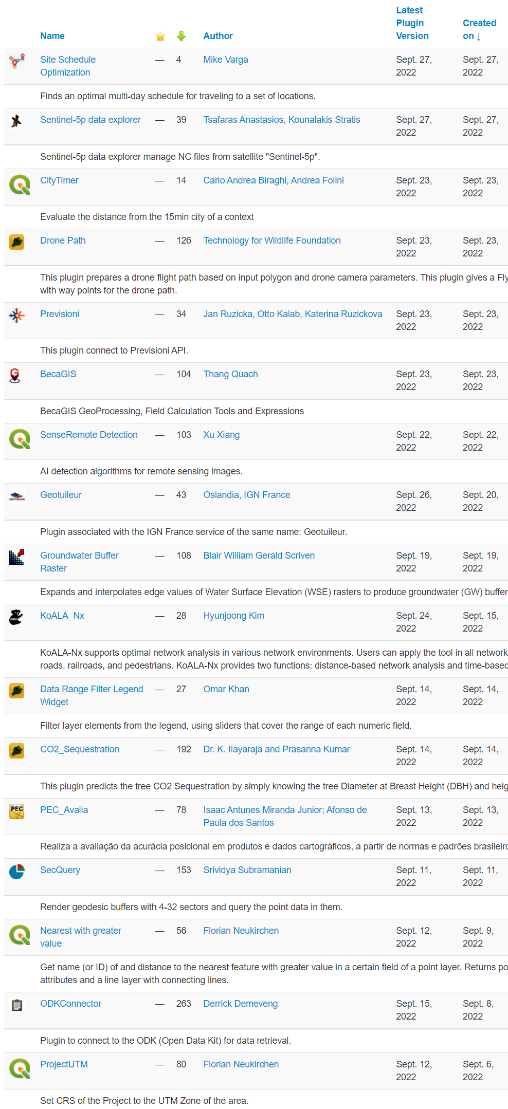
| Site Schedule Optimization |
| Finds an optimal multi-day schedule for traveling to a set of locations. |
| Sentinel-5p data explorer |
| Sentinel-5p data explorer manage NC files from satellite “Sentinel-5p”. |
| CityTimer |
| Evaluate the distance from the 15min city of a context |
| Drone Path |
| This plugin prepares a drone flight path based on input polygon and drone camera parameters. This plugin gives a Fly Litchi compatible csv file with way points for the drone path. |
| Previsioni |
| This plugin connect to Previsioni API. |
| BecaGIS |
| BecaGIS GeoProcessing, Field Calculation Tools and Expressions |
| SenseRemote Detection |
| AI detection algorithms for remote sensing images. |
| Geotuileur |
| Plugin associated with the IGN France service of the same name: Geotuileur. |
| Groundwater Buffer Raster |
| Expands and interpolates edge values of Water Surface Elevation (WSE) rasters to produce groundwater (GW) buffer rasters |
| KoALA_Nx |
| KoALA-Nx supports optimal network analysis in various network environments. Users can apply the tool in all network environments, such as roads, railroads, and pedestrians. KoALA-Nx provides two functions: distance-based network analysis and time-based network analysis |
| Data Range Filter Legend Widget |
| Filter layer elements from the legend, using sliders that cover the range of each numeric field. |
| CO2_Sequestration |
| This plugin predicts the tree CO2 Sequestration by simply knowing the tree Diameter at Breast Height (DBH) and height of the tree. |
| PEC_Avalia |
| Realiza a avaliação da acurácia posicional em produtos e dados cartográficos, a partir de normas e padrões brasileiros |
| SecQuery |
| Render geodesic buffers with 4-32 sectors and query the point data in them. |
| Nearest with greater value |
| Get name (or ID) of and distance to the nearest feature with greater value in a certain field of a point layer. Returns point layer with added attributes and a line layer with connecting lines. |
| ODKConnector |
| Plugin to connect to the ODK (Open Data Kit) for data retrieval. |
