So February came and went without us sharing our monthly plugin update. That means, this post lists a whopping 32 new plugins that have been published in the QGIS plugin repository in February and March.
Here’s the quick overview in reverse chronological order. If any of the names or short descriptions piques your interest, you can find the direct link to the plugin page in the table below the screenshot.
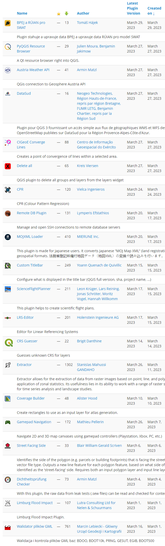
| BPEJ a RÚIAN pro SWAT |
| Plugin stahuje a upravuje data BPEJ a upravuje data RÚIAN pro model SWAT |
| PyQGIS Resource Browser |
| A Qt resource browser right into QGIS. |
| Austria Weather API |
| QGis connection to Geosphere Austria API |
| DataSud |
| Plugin pour QGIS 3 fournissant un accès simple aux flux de géographiques WMS et WFS des données OpenStreetMap publiées sur DataSud pour la Région Provence-Alpes-Côte-d’Azur. |
| CIGeoE Converge Lines |
| Creates a point of convergence of lines within a selected area. |
| Delete all |
| QGIS plugin to delete all groups and layers from the layers widget |
| CPR |
| CPR (Colour Pattern Regression) |
| Remote DB Plugin |
| Manage and open SSH connections to remote database servers |
| MOJXML Loader |
| This plugin is made for Japanese users. It converts Japanese “MOJ Map XML” (land registration polygon data) into geospatial formats. 法務省登記所備付地図データ(地図XML)の変換や読み込みを行います。 |
| Custom TitleBar |
| Configure what is displayed in the title bar (QGIS full version, sha, project name, …) |
| ScienceFlightPlanner |
| This plugin helps to create scientific flight plans. |
| LRS-Editor |
| Editor for Linear Referencing Systems |
| CRS Guesser |
| Guesses unknown CRS for layers |
| Extractor |
| Extractor allows for the extraction of data from raster images based on point, line, and polygon vectors and the application of zonal statistics. Its usefulness lies in its ability to work with a range of raster sources, making it ideal for time series analysis and landscape studies. |
| Coverage Builder |
| Create rectangles to use as an input layer for atlas generation. |
| Gamepad Navigation |
| Navigate 2D and 3D map canvases using gamepad controllers (Playstation, Xbox, PC, etc.) |
| Street Facing Side |
| Identifies the side of the polygon (e.g. parcels or building footprints) that is facing the street, river, or any other line vector file type. Outputs a new line feature for each polygon feature, based on what side of the polygon was identified as the ‘street-facing’ side. Requires both an input polygon layer and input line layer. |
| Dichtheitsprüfung Checker |
| With this plugin, the raw data from leak tests (.sew files) can be read and checked for content. |
| Limburg Flood Impact |
| Limburg Flood Impact Plugin. |
| Walidator plików GML |
| Walidacja i kontrola plików GML baz: BDOO, BDOT10k, PRNG, GESUT, EGiB, BDOT500 |
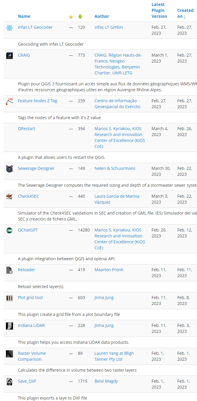
| infas LT Geocoder |
| Geocoding with infas LT Geocoder |
| CRAIG |
| Plugin pour QGIS 3 fournissant un accès simple aux flux de données géographiques WMS/WMTS et WFS du CRAIG et d’autres ressources géographiques utiles en région Auvergne Rhône-Alpes. |
| Feature Nodes Z Tag |
| Tags the nodes of a feature with it’s Z value |
| QRestart |
| A plugin that allows users to restart the QGIS. |
| Sewerage Designer |
| The Sewerage Designer computes the required sizing and depth of a stormwater sewer system. |
| Check4SEC |
| Simulator of the Check4SEC validations in SEC and creation of GML file. (ES) Simulador del validador Check4SEC de la SEC y creación de fichero GML. |
| QChatGPT |
| A plugin integration between QGIS and openai API. |
| Reloader |
| Reload selected layer(s). |
| Plot grid tool |
| This plugin create a grid file from a plot boundary file |
| Indiana LiDAR |
| This plugin helps you access Indiana LiDAR data products. |
| Raster Volume Comparison |
| Calculates the difference in volume between two raster layers |
| Save_DXF |
| This plugin exports a laye to DXF file |
