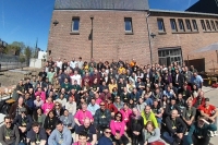
Last week, we had our 25th Contributor Meeting in ‘s-Hertogenbosch, The Netherlands. Prior to the meeting, the International QGIS User… Read more Reporting Back From the User Conference & Contributor Meeting in Den Bosch


Last week, we had our 25th Contributor Meeting in ‘s-Hertogenbosch, The Netherlands. Prior to the meeting, the International QGIS User… Read more Reporting Back From the User Conference & Contributor Meeting in Den Bosch
Dear QGIS Community, We are very pleased to announce that this year’s round of grants is now available. The call… Read more QGIS Grants #8: Call for Grant Proposals 2023

On January 16th, we launched the largest crowd-funding call for QGIS.ORG so far. Our goal was to increase sustaining membership… Read more Crowd-Funding 2023 Results
So February came and went without us sharing our monthly plugin update. That means, this post lists a whopping 32… Read more Plugin Update February & March 2023
With the QGIS Grant Programme 2022, we were able to support four proposals that are aimed to improve the QGIS… Read more Reports from the winning grant proposals 2022

It is with great pleasure that we would like to welcome Felt as our first flagship sustaining member! Felt plays… Read more Welcoming our first flagship sustaining member – Felt

We are pleased to announce the release of QGIS 3.30 ‘s-Hertogenbosch! Installers for all supported operating systems are already out.… Read more QGIS 3.30 ‘s-Hertogenbosch is released!

In a few weeks, our 25th Contributor Meeting and International QGIS User Conference uc2023.qgis.nl will take off on 18 April.… Read more Getting ready for our user conference and contributor meeting in ‘s-Hertogenbosch

An amazing 30 new sustaining members have already answered our crowd-funding call raising total member contributions to €158,000 annually. We… Read more Status Update on 2023 Crowd-Funding
This month has been busy with 20 new plugins in the QGIS plugin repository. Since it can be challenging to… Read more Plugin Update January 2023